By John Cornelison on
2/23/2014 6:38 AM
 Friday February 21, 2014, the Federal Communications Commission (FCC) approved Voice of Vashon’s (VoV) application for an FM radio station – along with over 1000 other low-power FM applicants nationwide. Fourteen years ago a small group of volunteers dared to dream that Vashon could have its own live radio voice. Now, that dream has come true. While much of the infrastructure is in place for the station to go live, a new FM...
|
By John Cornelison on
1/21/2014 7:42 AM
Free Preparedness Workshop  From VashonBePrepared & Vashon Chamber of Commerce Monday January 27th 6:30 to 8:30pm Land Trust building (10014 SW Bank Rd.) Advance Registration Required so Click Here: http://goo.gl/n1bLPg Prepare Your Business for Disaster & Disruption. 40% of businesses do not reopen after a disaster and an additional 25% go dark within one year according to FEMA. Especially important...
|
By John Cornelison on
1/7/2014 7:55 AM
 “For the first time in two decades, the world's costliest natural disasters in 2013 were not in the USA, according to a report released today by Munich Re, the world's largest reinsurance firm. Last year, the most expensive weather disasters were in Europe, which...
|
By John Cornelison on
1/6/2014 1:46 PM
 A graph showing the relationship between eruption volume and time between eruptions, using the models presented in Carrichi and others (2014). Notice how for buoyancy-driven eruptions (in blue), the time between eruptions doesn’t vary much across a wide range of volumes. Image: Figure 3 from Caricchi and others (2014), Nature Geoscience. The study’s upshot is that Yellowstone Caldera (and the other 20+ supervolcano sites) are more likely than previously thought to explode without the aid of an earthquake. A big one could drastically lower global...
|
By John Cornelison on
11/7/2013 8:11 AM
|
By John Cornelison on
11/5/2013 8:58 AM
 The Northwest faces poorer forest health (more forest fires), earlier snowmelt (lower stream flows) and raised sea levels (eroding coasts), according to Monday’s release of the Northwest Climate Assessment Report (NWCAR, 2013). Impacts might total some $14 billion dollars...
|
By John Cornelison on
10/22/2013 7:59 AM
VashonBePrepared Community Summit  Leaders from the Vashon community came together for the first VashonBePrepared Community Summit Saturday morning at Chautauqua School. Moderated by President Rick Wallace and Vice-President Bob Smueles, the group brainstormed for over 3 hours on current community need if a disaster were to befall us. Specifically the group...
|
By John Cornelison on
10/18/2013 4:34 PM
 Saturday VashonBePrepared will hold it’s annual membership meeting, open to the public, from 8:30 am – noon at Chautauqua Elementary School. Purpose Develop a consensus among the community leaders on: What the Island community needs to survive and recover from an incident that would impact the entire community, and How best to meet those needs. This will be followed by the requisite VashonBePrepared...
|
By John Cornelison on
10/18/2013 4:13 PM
|
By John Cornelison on
9/16/2013 4:44 PM
 You can share your views about transportation needs with Senate Transportation Committee members at public forums on Tuesday, Sept. 17 in Bellevue and Monday, Oct. 14 in downtown Seattle. These “listening sessions” are part of a statewide tour hosted by the Washington State Department of Transportation. At least half of each meeting...
|
By John Cornelison on
9/12/2013 8:12 PM
 King County has told the local cities that it does not plan to provide snowplowing services to Tier 2 through 5 roads this winter due to budget cuts. Click here to see which roads in unincorporated King County are currently identified as Tier 1 through 5, and to see contact information for questions. (Hint only Vashon Highway is rated as a tier one road.) The County may in fact plow as resources become available, but is suggesting that it may not be in a timely fashion. Details on the county’s ice & snow program can be found at: www.kingcounty.gov/transportation/kcdot/Roads/SnowAndIce.aspx We are unaware of actual staffing changes locally so...
|
By John Cornelison on
9/10/2013 7:22 AM
BY THE PRESIDENT OF THE UNITED STATES OF AMERICA A PROCLAMATION  Time and again, America faces crises that test our readiness and challenge our resolve -- from natural disasters like hurricanes, tornadoes, and floods to shootings, cyber incidents, and even acts of terrorism. While my Administration is working tirelessly to avert national tragedies, it is every American's responsibility to be prepared. By planning for emergencies, individuals can protect themselves...
|
By John Cornelison on
9/5/2013 10:03 AM
While scientists can't predict when a great earthquake producing a pan-Pacific tsunami will occur, thanks to new tools being developed by federal and state officials, scientists can now offer more accurate insight into the likely impacts when tsunamis occur. This knowledge can lead officials and the public to reduce the risk of the future tsunamis that will impact the west coast.  Maximum current speeds for the Port of Los Angeles (POLA) and the Port of Long Beach (POLB), according to the SAFRR Tsunami Scenario. In the POLA, currents are strongest at Angels Gate, the Cabrillo Marina, the Boat Yard, and the old Navy Yard. Once...
|
By John Cornelison on
8/7/2013 8:28 AM
 Wireless Emergency Alerts (WEAs) provide free notifications of imminent threats to safety or missing persons to your mobile device. In order to receive WEAs, you must have a capable device and be located in an area (e.g., county) targeted by Authorized Senders to receive one of 3 types of alerts: Presidential Alerts – Alerts issued by the President or a designee; Imminent Threat Alerts – Alerts that include severe man-made or natural disasters, such as hurricanes, earthquakes, tornadoes, etc., where an imminent threat to life or property exists; and AMBER Alerts– Alerts that meet the U.S. Department of Justice's criteria to help law enforcement search for and locate...
|
By John Cornelison on
7/15/2013 7:55 AM
 As our culture becomes ever more dependent on electricity, the current distribution system has a huge vulnerability – induced current from external electrical flux. One source of such an Electro Magnetic Pulse (EMP) would be a nuclear bomb (or a dedicated gamma ray bomb that North Korea...
|
By John Cornelison on
7/11/2013 1:30 PM
|
By John Cornelison on
7/5/2013 7:50 AM
|
By John Cornelison on
7/4/2013 1:13 PM
Overview of Vashon's Status and Systems for Disaster Response  This 3-hour overview, VashonBePrepared 101, is a great introduction to the systems in place on Vashon for major disasters, and an update on the status of our readiness. It's free and open to the public, with a packed agenda covering all the components we have assembled here to work in partnership...
|
By John Cornelison on
6/24/2013 9:56 AM
 Some 50 cyclists tested their disaster preparedness skills at the 1st Seattle Disaster Relief Trial. It was held near the University of Washington on June 21st. According to their Facebook event listing: “Imagine a 7.2-magnitude earthquake hitting the Seattle Fault. Freeway overpasses crumble, a Lake Washington sieche (oscillating wave) takes chunks out of bridges. Motor vehicles are rendered useless, but following the example of Sandy Relief by bike, Seattle residents with bikes and trailers or cargo bikes are able to transport food and medical...
|
By John Cornelison on
6/21/2013 9:27 AM
 The U.S. National Climatic Data Center’s (NCDC) announced that according to their 2012 weather and climate disasters information, 2012 saw 11 weather and climate disaster events each with losses exceeding $1 billion in damages. This makes 2012 the second costliest year since 1980, with a total of more than $110 billion in damages throughout the year. The 2012 total damages rank only behind 2005, which incurred $160 billion in damages due in part to four devastating land-falling hurricanes. The 2012 billion-dollar events included seven severe weather and tornado events, two tropical...
|
By John Cornelison on
6/17/2013 10:39 AM
|
By John Cornelison on
6/17/2013 6:09 AM
 Last October, the American Red Cross released a free Wildfire App for iPhone and Android platforms, which allows users to track blazes this summer. Features: • Step-by-step instructions let you know what to do even before/during/after an wildfire, even if no data connectivity. • Get notified about current wildfires or wildfire-conducive weather. • Let family and friends know...
|
By John Cornelison on
6/14/2013 10:07 AM
 If you have even been curious about the potential impact of all those various earthquakes that geologists have identified – and see which might have the largest impact for a general region like Vashon Island (i.e., parcel level damage estimates are NOT supported!), then check out the State Seismic Hazards Catalog. ...
|
By John Cornelison on
6/14/2013 8:28 AM
Canadian scientists apply new methods to better understand Pacific coast earthquakes  Understanding the size and frequency of large earthquakes along the Pacific coast of North America is of great importance, not just to scientists, but also to government planners and the general public. The only way to predict the frequency and intensity of the ground motion expected from large and giant "megathrust " earthquakes along Canada's west coast is to analyze the geologic record. A new study...
|
By John Cornelison on
6/14/2013 6:34 AM
 The Vashon Maury Island Radio Club and VashonBePrepared invites the public to visit Vashon’s amateur radio volunteers at our 2013 Field Day event. Vashon Hams gather at Sunrise Ridge on June 22 & 23 for Field Day’s 80th anniversary to compete in the largest single amateur radio and emergency preparedness exercise, with over 35,000 operators participating throughout the US & Canada. Local ham volunteers...
|
By John Cornelison on
2/12/2013 3:04 AM
 Every spring in Tacoma there is a great conference for meeting and sharing ideas with a wide range of disaster experts. Early Bird Registration closes at the end of the month! Why Attend Successful management of emergencies can only be accomplished through effective and pre-established partnerships. This conference offers you the opportunity to develop those relationships; gain the necessary information to develop your response, recovery, and mitigation plans; create your preparedness messaging to those you serve; and gain valuable insight into lessons learned and established best practices. This is the largest and most successful regional emergency management preparedness conference in the Pacific Northwest – attracting attendees from: Emergency...
|
By John Cornelison on
1/24/2013 9:26 AM
 The Federal Emergency Management Agency (FEMA) National Earthquake Hazards Reduction Program (NEHRP) is pleased to announce a 1 ½ hour webinar on Reducing the Risks of Nonstructural Earthquake Damage (FEMA E-74). Please join and share this opportunity with other individuals and organizations who might be interested. See details below and in the attachment. Webinar Description Nonstructural components of buildings include all elements that are not part of the structural...
|
By John Cornelison on
1/19/2013 4:53 PM
 Congratulations to Vashon islander Daniel Luechtefeld for Training to support his community, Volunteering (with VashonBePrepared, VIFR, VMIRC, ARES and other community organizations), Responding and actually saving a neighbor’s life, and Volunteering to help make a video of that dramatic rescue. Daniel has served on the VashonBePrepared Board for a couple years now as the Vashon Maury Island Radio Club (VMIRC)’s...
|
By John Cornelison on
1/3/2013 8:32 AM
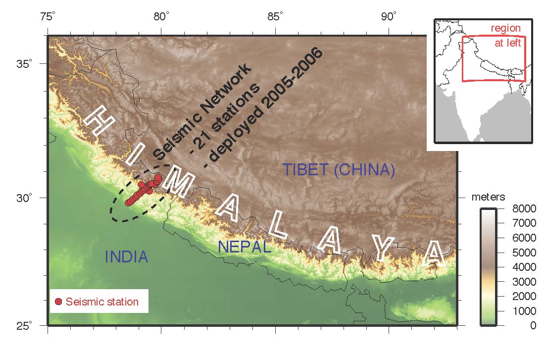
 The Main Himalayan Thrust has historically been responsible for a magnitude 8 to 9 earthquake every several hundred years. (Illustration: Warren Caldwell) Will a megathrust earthquake strike the NW in 2013? New Years brings out speculators, and this time it is the Seattle PI, which quotes the Pacific Northwest Seismic Network’s director John Vidale and Stanford University geophysics professor Paul Segall whose studies indicate some potential links between "episodic tremor and slip,"or ETS activity and subsequent quakes. According to the Stanford release: ...
|
By John Cornelison on
12/7/2012 10:22 AM
|