John's Vashon Preparedness Blog

All of John Cornelison's blogs are listed on this page chronologically. Use the Calendar or Search functions in the right column to search through time, via keyword, or look at the parent blog page to view all authors' posts.

John's Recent Blogs

Author: Created: 6/15/2010 5:35 PM RssIcon
Disaster news and links of interest for Vashonites
By John Cornelison on 1/24/2013 9:26 AM
imageThe Federal Emergency Management Agency (FEMA) National Earthquake Hazards Reduction Program (NEHRP) is pleased to announce a 1 ½ hour webinar on Reducing the Risks of Nonstructural Earthquake Damage (FEMA E-74). Please join and share this opportunity with other individuals and organizations who might be interested. See details below and in the attachment.

Webinar Description Nonstructural components of buildings include all elements that are not part of the structural...
By John Cornelison on 1/19/2013 4:53 PM
JustBeThere.infoCongratulations to Vashon islander Daniel Luechtefeld for

Training to support his community, Volunteering (with VashonBePrepared, VIFR, VMIRC, ARES and other community organizations), Responding and actually saving a neighbor’s life, and Volunteering to help make a video of that dramatic rescue. Daniel has served on the VashonBePrepared Board for a couple years now as the Vashon Maury Island Radio Club (VMIRC)’s...
By John Cornelison on 1/3/2013 8:32 AM
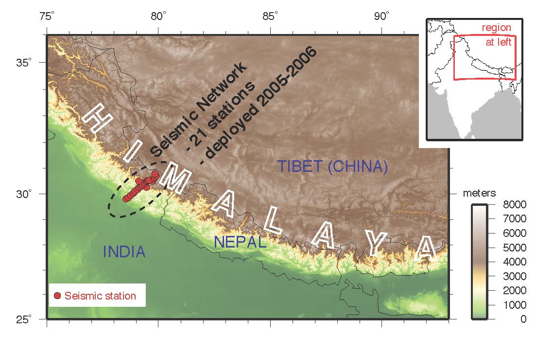
The Main Himalayan Thrust has historically been responsible for a magnitude 8 to 9 earthquake every several hundred years. (Illustration: Warren Caldwell)


Will a megathrust earthquake strike the NW in 2013? New Years brings out speculators, and this time it is the Seattle PI, which quotes the Pacific Northwest Seismic Network’s director John Vidale and Stanford University geophysics professor Paul Segall whose studies indicate some potential links between "episodic tremor and slip,"or ETS activity and subsequent quakes.

According to the Stanford release:

...
By John Cornelison on 12/7/2012 10:22 AM
SandyBarametricMap-NOAAIn an admittedly narrow look at just one operation during Super Storm Sandy, professional disaster professionals wasted several days waiting for deployment. Fox’s sensational article...
By John Cornelison on 10/30/2012 7:44 AM
10-30-2012 at 8.38.48 AMWorkers at the University of Washington’s Seismology Lab have concern that the 7.7 magnitude earthquake that occurred on the British Columbia coast over the weekend may pretend future seismic activity in Washington. As reported at King5:

“Earthquakes trigger...
By John Cornelison on 10/8/2012 9:40 AM
Congrats to the variety of people (but especially Randall Bardwell with assistance by Tim Hardy) for huge new progress on getting a second repeater up and (soon) operational for Vashon’s amateur radio community. While it will be able to serve as a backup to the existing W7VMI club repeater, it also is vastly more modern with a super flexible architecture that will allow a much broader array of services and modes in the future. This likely will play a role in enhancing emergency communications in coming years.

Rick Wallace was instrumental in coordinating the Sun rise Ridge board, Voice of Vashon PSE and Potelco to obtain permission and actually get the new antennas installed as shown to the right.

See all his photos, a video, and read more...
By John Cornelison on 10/8/2012 8:57 AM


On Saturday October 13, from 10 a.m. to 2 p.m. Vashon Island Fire & Rescue will open its doors to the public for their annual Open House at the end of Fire Prevention Week.

There will be a flu shot clinic from getaflushot.com, training demonstrations at the Penny Farcy Training Center across the street, "hands on" the fire hose, as well as displays by VashonBePrepared, CERT and the Red Cross.

The following items will be for sale: WHAT'S COOKIN' AT VIFR cookbook; bike, skating, equestrian and ski helmets; "blue" address signs and registration for upcoming CPR classes.

2012 FPW

...
By John Cornelison on 9/28/2012 6:48 AM
Dongshi - September 20, 1999 Nantou Taiwan earthquake  - Image Credit: NOAA National Geophysical Data CenterAfter April’s huge strike-slip earthquake, the USGS reiterated the one earthquake doesn’t jolt others (out of the region) into existence.

However Fred Pollitz of the U.S. Geological Survey is now reporting...
By John Cornelison on 9/25/2012 8:55 AM
iPhone Screenshot 2Be ready for an earthquake with Earthquake by American Red Cross. Get notified when an earthquake occurs, prepare your family and home, find help and let others know you are safe even if the power is out – a must have for anyone who lives in an earthquake-prone area or has loved ones who do.

FEATURES: •Step-by-step instructions let you know what to do even before/during/after an earthquake, even if no data connectivity. •Get notified when an earthquake occurs; see the intensity impact to your area or those of loved-ones with notifications generated by the United States Geological Survey (USGS). •Let family and friends know you are okay with the customizable “I’m Safe” alert for Facebook, Twitter, email and text. •Find open Red...
By John Cornelison on 9/14/2012 9:04 AM
President Obama has declared 20 more disasters than in 2010 and 2 times the numbers declared by President George W. Bush in his first two years in the White House.

Are there really that many more disasters though? Despite all the severe weather this year and portent for much more ahead (partially due to massive declines in Artic Ice levels) and resultant economic losses (e.g., a huge downturn in salmon runs), there may also be some politics at play, with Obama being pressured to declare disasters according to this ABC News report.

By John Cornelison on 9/1/2012 7:30 AM
President Obama has proclaimed September as National Preparedness Month.

Who Ya Gonna CallA 2009 Citizen Corps National Survey revealed only 57% of Americans have supplies set aside in their homes just for disasters, and only 44% have a household emergency plan.

...
By John Cornelison on 9/1/2012 7:11 AM

U.S. seismologists at CA’s Scripps Institution of Oceanography have released a study indicating fault zones weaken in select locations shortly after a fault reaches an earthquake tipping point. This can then transform a smaller series of quakes into a large mega-quake.

Read more: http://www.upi.com/Science_News/2012/08/30/Study-Hot-spots-may-up-earthquake-size/UPI-89401346363108/

By John Cornelison on 8/31/2012 7:49 AM
You only have seconds. Do you know exactly what to do the moment the ground starts shaking? If it involves a doorway, a triangle, or running – these are not quake-safe actions. Register now at www.ShakeOut.org/washington/register to learn more and practice updated quake safety. Be a part of Washington’s ShakeOut drill.

You are invited to join thousands of people who will Drop, Cover, and Hold On on October 18th at 10:18 a.m. in the 2012 Great Washington ShakeOut!

More than 12.5 million people were registered...
By John Cornelison on 8/27/2012 6:21 AM


The CERT equestrian group is ready to help at a recent drill. From left are Penni Symonds, Beth Kellner, Wanda Moore and Mary O’Brien. Craig Harmeling will join the team soon - Courtesy PhotoThe Vashon Beachcomber has just published a nice story about CERT’s new equestrian team which has been organized by Beth Kellner with help from Penni Symonds, Wanda Moore,...
By John Cornelison on 8/27/2012 6:08 AM


Vashon EOC in full operation during the June 5th 2012 Evergreen Quake Exercise. Photo ff_1283063 by John CornelisonAfter some 7 years in a conference room in VIFR’s main Station 55, the Vashon Emergency Operations Center (EOC) may be relocated next year to the VIFR Association Building across the street. Slightly larger, the room would be shared with King County...
By John Cornelison on 8/2/2012 9:48 AM


Drought over western North America from 800 to 2100.Western North America experienced the strongest drought in 800 years from 2000 to 2004 – but that may be the new normal for the next century. Reduction in carbon uptake during turn of the century drought in western North America – pg 551 – 556,...
By John Cornelison on 7/28/2012 12:44 PM


LocalFaults.800x490U.S. Geological Survey’s Brian Atwater has found evidence of a powerful tsunami near Bremerton recently – due to an earthquake which was “much more dangerous than previously thought”. Their conclusion: climb to safety after an earthquake.

Watch or read the full story at: www.q13fox.com/news/kcpq-scientist-massive-quake-struck-area-1000-years-ago-could-happen-again-20120716,0,6181048.story

By John Cornelison on 7/27/2012 11:53 AM


Barb Graff, Director of Seattle’s Office of Emergency Management has just announced the hire of Tracy Connelly as Seattle Office of Emergency Management’s new Community Planning Coordinator. Tracy starts August 1st.

Tracy Connelly has been a Public Outreach Specialist at OEM working with access and functional needs, immigrant and refugee, homeless, and multi-cultural populations.

Citywide_hub_locations2small10-11In...
By John Cornelison on 7/27/2012 8:00 AM


Funny that DHS is getting criticism for NOT using drones, when my take is that drones further compromise our civil freedoms, but apparently their use helps some key corporations' bottom lines – and their use can be more palatable by using them for Disaster Response.

According to Homeland Security Department Secretary Janet Napolitano, they are considering drone use to gather situational awareness for forest fires or “large public safety” matters.

Anyways, here’s one story:

www.nextgov.com/defense/2012/07/homeland-security-experiment-rescue-drones-inside-united-states/57023/

another citing the value of drones:

www.stripes.com/news/spies-in-the-north-dakota-sky-signal-a-new-age-of-surveillance-1.184116...
By John Cornelison on 7/26/2012 8:58 AM


Department of Homeland Security Seal - Emergency Management Institute LogoAs they indicate below, this appears to be a pretty basic course, but by clicking on one of the initial pages you can see much of the complete course outline and quickly skim it to see how much of it is applicable to your family or business.

This outline serves as a great reminder of all the steps we should be taking – and a reminder for us to complete those missing action items that we’d not completed (or refreshed) recently!

The Federal Emergency Management Agency (FEMA) is pleased to announce a new web-based, independent study training course, IS-325—Earthquake Basics: Science, Risk, and Mitigation.

...
By John Cornelison on 7/26/2012 7:39 AM
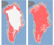

These undated handout images provided by NASA shows the extent of surface melt over Greenland’s ice sheet on July 8, left, and July 12, right. Measurements from three satellites showed that on July 8, about 40 percent of the ice sheet had undergone thawing at or near the surface. In just a few days, the melting had dramatically accelerated and an estimated 97 percent of the ice sheet surface had thawed by July 12. In the image, the areas classified as “probable melt” (light pink) correspond to those sites where at least one satellite detected surface melting. The areas classified as “melt” (dark pink) correspond to sites where two or three satellites detected surface melting. Nearly every part of the massive Greenland ice sheet suddenly and strangely melted a bit this month in a freak event that concerned scientists had never witnessed before. NASA says three different satellites saw what it calls unprecedented melting from July 8 to July 12. Most of the thick ice remains, but what was unusual was the widespread area where some melting occurred. (AP Photo/Nicolo E. DiGirolamo, SSAI/NASA GSFC, and Jesse Allen, NASA Earth ObservatoryAccording...
By John Cornelison on 7/23/2012 10:38 AM


Puget_Sound_earthquakesThe University of Washington Seismology Lab, has released a new map of major semi-recent quakes and fault lines around Puget Sound.

Read more about this at: www.heraldnet.com/article/20120722/BLOG48/707229962#Major-modern-quakes-of-Puget-Sound

I still...
By John Cornelison on 6/21/2012 5:43 AM


Cancel another innovative idea. According to a commentary published Monday in Proceedings of the National Academy of Sciences, storing harmful carbon dioxide gas underground is not practical. Why? Because it would cause earthquakes!

There is a long history of materials pumped underground causing earthquakes, and this report apparently finds this also likely in this situation. Although the quakes would likely be relatively small – they would be large enough to destroy the equipment used to pump the greenhouse gases down.

Read more in the LA Times article, which ends up quoting experts encouraging putting development funds into renewable energy instead. That makes sense to me!

...
By John Cornelison on 6/15/2012 10:31 AM


6-15-2012 at 11.30.25 AMThe Vashon Beachcomber has done a nice article on a key aspect of last week’s 2012 Evergreen Quake exercise. Entitled, “Emergency drill shows a marine lifeline could be established for Vashon”, Editor and author Leslie Brown included a number of great quotes from islanders and county officials...
By John Cornelison on 6/15/2012 9:46 AM


VIFRChief Hank Lipe has announced the hiring of Ms. Nicole Trent of Gig Harbor, WA to serve as an Administrative Assistant at Vashon Island Fire & Rescue – King County Fire District 13. A nine year veteran with Pierce County Fire District #16 (Key Peninsula), Nicole brings  a solid background in Fire District administrative services and is excited to become part of VIFR’s team.

Mark your...
By John Cornelison on 6/7/2012 2:35 PM


Drill includes delivering critical supplies to Vashon Island by boat

6-7-2012 at 3.24.59 PMKing County joined with federal, state, and local agencies this week to test its capacity to respond to and recover from a major earthquake. The exercise, dubbed “Evergreen Quake 2012,” gave participants a chance to assess their disaster response plans and emergency communication strategies. Six counties, including King County, participated in the drill, along with the state of...
By John Cornelison on 6/7/2012 11:19 AM


ff_1283059Nearly a hundred islanders took part in the regional Evergreen Quake on June 5th & 6th at the Vashon Emergency Operations Center.

It was fairly historic for a number of reasons:

- Initial test of Operation Lifeline (King County’s redirecting their passenger ferry or hiring a barge – to support emergency needs on Vashon) - The Planning Section has adopted the standard ICS Planning Clock - and had the 1st real run-though of this during a major exercise - The Public Information Team...
By John Cornelison on 6/7/2012 8:43 AM


If you like maps and haven’t checked out the Washington State Geologic Information Portal, it is a wealth of useful information! More than just interactive maps, they also have geoscience data and collections and links to other earth science information sites.

Of especial interest to Vashon residents might be the geologic map (showing faults on the surface, liquefaction, of geologic structures), the landslide map, and the subsurface geology map.

DNR-WAInteractiveGeologicMapDNR-LandslidesOfWAStateDNR-SubsurfaceGeologyInfoSystem

By John Cornelison on 6/7/2012 8:00 AM


RainierLahars.WA_DNR6Jun12Every 500-1000 years the slopes of Mount Rainier produce liquefied mud flows called lahars that can flow like rivers but have a density similar to liquid concrete. Based on the last Electron Mudflow ~550 years ago, and using HAZUS software, the DNR...

Read More Blogs, Read More Blogs

Eager to review even more blogs?!

  • Try the Blog Calendar, above on the right, to view blogs from previous months (the above list shows the 15 blogs starting with the date selected.)
  • Use the Tag Cloud to view blogs that share the selected topic (or tag).
  • Search for specific words of interest, using the Search Blogs tool, above on the right.

Search Blogs

Blog Calendar

Archive
<January 2013>
SunMonTueWedThuFriSat
303112345
6789101112
13141516171819
20212223242526
272829303112
3456789
Monthly
February 2024 (1)
June 2023 (2)
May 2023 (1)
March 2023 (2)
December 2022 (1)
October 2022 (1)
July 2022 (2)
June 2022 (1)
March 2022 (1)
February 2022 (2)
January 2022 (2)
December 2021 (1)
November 2021 (1)
September 2021 (3)
August 2021 (4)
July 2021 (6)
June 2021 (7)
April 2021 (2)
March 2021 (2)
February 2021 (1)
January 2021 (1)
September 2020 (2)
June 2020 (1)
May 2020 (5)
April 2020 (15)
March 2020 (9)
January 2020 (1)
April 2019 (1)
March 2019 (1)
July 2018 (2)
June 2018 (1)
March 2018 (2)
February 2018 (1)
October 2017 (1)
September 2017 (1)
June 2017 (2)
March 2017 (1)
February 2017 (2)
January 2017 (2)
November 2016 (2)
October 2016 (5)
September 2016 (3)
June 2016 (1)
May 2016 (2)
September 2015 (1)
June 2015 (1)
April 2015 (1)
March 2015 (2)
December 2014 (3)
November 2014 (5)
October 2014 (2)
September 2014 (1)
August 2014 (4)
July 2014 (3)
June 2014 (2)
May 2014 (5)
April 2014 (2)
March 2014 (1)
February 2014 (1)
January 2014 (3)
November 2013 (2)
October 2013 (3)
September 2013 (4)
August 2013 (1)
July 2013 (4)
June 2013 (7)
February 2013 (1)
January 2013 (3)
December 2012 (1)
October 2012 (4)
September 2012 (5)
August 2012 (4)
July 2012 (6)
June 2012 (11)
May 2012 (8)
April 2012 (11)
March 2012 (18)
February 2012 (11)
January 2012 (8)
December 2011 (4)
November 2011 (5)
October 2011 (22)
September 2011 (6)
August 2011 (4)
July 2011 (7)
June 2011 (25)
May 2011 (23)
April 2011 (36)
March 2011 (15)
February 2011 (8)
January 2011 (9)
December 2010 (4)
October 2010 (2)
September 2010 (8)
August 2010 (1)
July 2010 (3)
June 2010 (11)
April 2010 (1)
October 2009 (1)

Go

Blog Categories

There are no categories in this blog.

Recent Comments

Re: What to do if you have confirmed or suspected COVID-19 or are worried that you may have COVID-19
No on ventilators. They require a paramedic to insert the tubes and at that point should be off island in a proper care facility. Low flow oxygen is easily available, but those needing it only for COVID should also be in a proper care facility.
Re: What to do if you have confirmed or suspected COVID-19 or are worried that you may have COVID-19
The large national company, Lab Corp, announced that they can do testing as of last Friday. I believe they are used by both clinics on the island. Local clinicians just do a nasal swab as I understand it and then send those in for testing. The test kits reside at the laboratory.

In addition other test facilities exist, but are unlikely to be used directly by island providers. Contact their websites and offices before you go in with any respiratory issues. Their information is likely to change frequently until more is known about the virus.

I don't know about ventilators, but will ask. Thanks for your comment!
Re: What to do if you have confirmed or suspected COVID-19 or are worried that you may have COVID-19
Will Vashon be getting testing kits soon in the hands of all doctors and first responders on island? Can the Gates Foundation help in this regard? Can we get the Neighborcare Clinic better prepared in this regard?

How many ventilators are on island? This is where critical shortages seem imminent.

TagCloud

manganelo